وبلاگ تخصصی زیرساخت اطلاعات مکانی (SDI)
علمی، آموزشی و خبری (ایران و جهان)وبلاگ تخصصی زیرساخت اطلاعات مکانی (SDI)
علمی، آموزشی و خبری (ایران و جهان)


یافته های کارگاه بهبود قابلیت استفاده از داده های مکانی
یافته های یک کارگاه با عنوان
International Workshop on Improving the Usability of Geospatial Data
Output from International Workshop on Improving the Usability of Geospatial Data held at Ordnance Survey (UK) on 14 June 2017, sponsored by EuroGeographics and EuroSDR is reported below:
This is what the workshop found:
- Quality metadata is often insufficient to communicate how usable or relevant a dataset is to a user, because it is either incomplete, not easily obtained, not understandable to the non-geospatial professional or it is ignored.
- Other industries have developed easy to understand visual metrics to communicate relevant information about the product (examples include: food, energy efficiency in white goods, and water consumption in dish washers).
- Geospatial information is increasingly being used by non-experts in many different domains. (sat-navs are a good example here).
- The experts identified that different use cases require different quality of data. What is essential for one may be irrelevant for another.
- What appears to be required are easily understandable quality metrics that relate to specific use cases to enable the user to assess whether the dataset is relevant to their use. Included in the information should be data regarding provenance and lineage.
- Visual metrics, including colour coding, are easily understood by all.
- There was some doubt amongst those present on whether the users (and sometimes producers) were able to receive and understand this information.
- It might be useful to allow users to rate a dataset so that others could see the feedback. For example. 5* - Easy to use, easy to download and free as well or 1* - Expensive and didn’t meet my need.
- There is a need for quality metadata to be machine readable
The outcome from the workshop was a proposal for combined activity between experts and research with feedback from users. It should be noted that this is not an academic exercise but a practical one.
Ref: GSDI Web Site
امضای تفاهمنامه همکاری در تبادل اطلاعات مکانی، نقشه و محصولات اختصاصی
در راستای توسعه همکاری های سازمان جغرافیایی وزارت دفاع و پشتیبانی نیروهای مسلح و سازمان نقشه برداری کشور ، تفاهم نامه ای در زمینه تبادل اطلاعات مکانی، نقشه و محصولات اختصاصی دو سازمان روز یکشنبه مورخ 18تیر ماه به امضای روسای دو مجموعه رسید.
بر اساس این تفاهم نامه قراراست این دو سازمان به مدت 5 سال درزمینه های متعددی من الجمله مواردزیرهمکاری مشترک داشته باشند: همکاری مشترک در بازنگری نقشه ها و اطلاعات مکانی موجود و تولید محصولات جدید، در زمینه علمی و پژوهشی، در اختیار قرار دادن تجهیزات فنی دو سازمان، همکاری در راه اندازی زیرساخت داده های مکانی در کشور.
اطلاعات بیشتر: سایت سازمان نقشه برداری کشور
نمونه ای از توانمندی داخلی- توسعه سامانه مرکز تبادل اطلاعات مکانی وزارت راه و شهرسازی
طی همایش ژئوماتیک 96 از غرفه وزارت راه و شهرسازی بازدیدی داشتم که حاصل آن آشنائی با سامانه متا این وزراتخانه بود. ارائه درصد همپوشانی از قابلیت های خوب این سامانه می باشد.


ارزیابی زیرساخت اطلاعات مکانی از منظر ریسک
مفاله ای منتشر شده در ژورنال تحقیقات زیرساخت های اطلاعات مکانی با عنوان اصلی :
Assessment of Spatial Data Infrastructure from a Risk Perspective
2016
Abstract
This research presents an operational framework to assess organizational Spatial Data Infrastructures (SDIs) from a risk perspective to develop a stable SDI. The core of the framework is constructed based on a survey, fuzzy inference system and cluster analysis, providing quantitative indicators to measure and prioritize the risks to SDI. This framework could mainly contribute to identifying, mitigating or avoiding the potential risks of different aspects of an SDI, such as spatial data and information, organizational and technological aspects. Additionally, it could be considered as an approach that supports multi-view SDI assessment framework toward a more comprehensive assessment of SDIs. A prototype implementation to assess and prioritize the risks of the spatial data and information demonstrates the framework merit, flexibility and usability for assessing the risks of SDI initiatives at different levels, such as organizational, local and national levels; however, the risks and SDIs change over time; thus, the development of stable SDI initiatives depends on a continuous process for coping with the risks.

کتاب مقالات کنفرانس SDI 2016 منتشر شد
This book is the result of a collaborative initiative between the Global Spatial Data Infrastructure Association (GSDI), the University of New Brunswick, the Centre for SDIs and Land Administration (CSDILA) in the Department of Infrastructure Engineering at the University of Melbourne and University of Luven. The articles featured in this peer-reviewed book were mostly the result of the traditional Call for Papers for the GSDI Geospatial World Conference Spatial Enablement in Smart Homeland, including three main topics of Smart Disaster Prevention, Smart Transportation and Smart City, but also contains contributions of full articles which were solicited for publication in this book.
نقشه وضعیت NSDIهای کشورهای دنیا
How many countries in the world have developed or are in the process of developing SDI and SDI like proposals that are/were prepared and being implemented in ‘various countries/organizations?
By: Munir Ahmad & Asmat Ali from Pakistan
More information: https://www.google.com/maps/d/viewer?mid=1596RIb8g_n0LPyi55-N1E2PuDw4

A New SDI Model & its Components
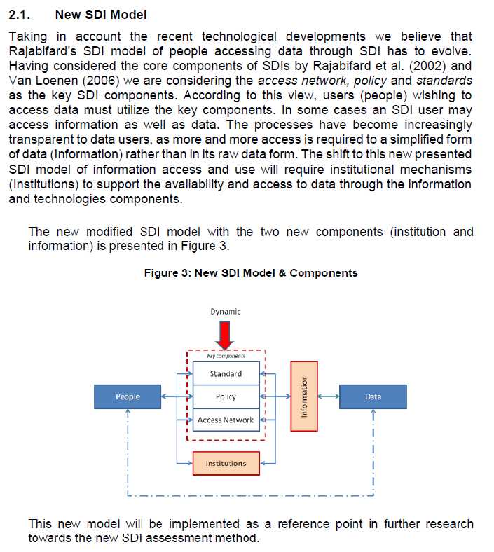
The STIG – A new SDI assessment method
Ref:International Journal of Spatial Data Infrastructures Research, 2015, Vol.10, 55-83