وبلاگ تخصصی زیرساخت اطلاعات مکانی (SDI)
علمی، آموزشی و خبری (ایران و جهان)وبلاگ تخصصی زیرساخت اطلاعات مکانی (SDI)
علمی، آموزشی و خبری (ایران و جهان)
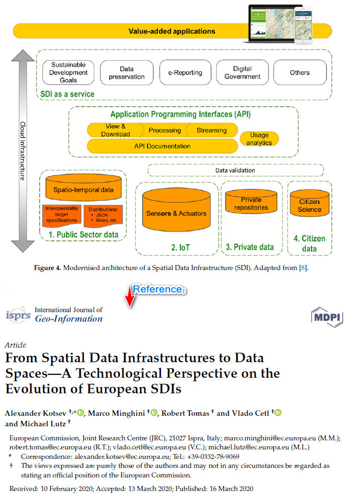
SDI در 3 ساعت با GeoNetwork
برای جزئیات دستورالعمل زیر را دانلود و مطالعه کنید.
GeoNetwork for dummies, or how to setup and use an SDI in 3 hours

GeoNetwork for dummies, or how to setup an SDI in 3 hours
The workshop will focus on the implementation of a GeoNetwork
opensource based catalog to serve and access geospatial data in a
Spatial Data Infrastructure.
A local catalog will be installed and configured. Harvesting of spatial
data resources from remote servers will be configured and geospatial web
map services will be set up using the embedded GeoServer and configured
for access through the catalog web interface.
Participants will create INSPIRE compliant metadata and learn how to
develop and use custom metadata templates based on the ISO19115/19119
metadata standards. Participants will use the catalog in different ways,
including the web interface and OGC-CSW ISO. The new ebRIM CSW ISO
interface, the OAI-MHP and GeoRSS protocols will be introduced.
Attention will also be given to import and export functionality of the
catalog that allow integration of the publishing process in existing
workflows like desktop GIS or operational data processing servers using
free and proprietary tools.
presenter
J. Ticheler, J. Garcia, H. Doeleman.
GeoCat
Reference: http://2010.foss4g.org/workshop12.php.html
مدت زیادی است که این دستورالعمل از سرور مربوطه حذف شده است . دستورالعمل در سال 1394 دانلود شده است.
راهبرد مکانی انگلستان برای سال های 2020 تا 2025
Geospatial Strategy for 2020 to 2025
بریتانیا (انگلستان) اخیراً یک استراتژی ملی 5 ساله مکانی را منتشر کرده است ، که فرصت ها ، روند داده ها و ماموریت های استراتژیک را برای پرداختن به چالش های فعلی داده های مکانی را بیان می کند. یک مورد مهم استراتژی انگلیس توانایی فنی و عملیاتی برای به اشتراک گذاری داده های مکانی در سراسر انگلستان است که از طریق زیرساخت داده های مکانی (SDI) اجرا می شود.
In order to maximise these opportunities, we need to respond to some fundamental technological changes. We identify six trends that are most likely to affect the use of location data. These include:
- the proliferation of cheap location sensors,
- increased connectivity,
- cloud computing and
- the rise of artificial intelligence.
YorkInfo : نمونه ای از SDI موفق در کانادا
شهرداری منطقه ای یورک در انتاریو کانادا به تازگی جایزه Esri را بخاطر ابتکار تصمیم گیری درباره اطلاعات خود با عنوان مشارکت YorkInfo ، به دست آورد. این مشارکت ، مردم ، فرایندها و فناوری های زیرساخت داده های مکانی (SDI) را شامل می شود و به منطقه اجازه می دهد تا به طور کارآمد یک منطقه بزرگ جغرافیایی دولت را اداره کرده و خدمات درجه یک را به ساکنان و مشاغل منطقه ارائه دهد. در این پست وبلاگ ، Gordon Plunkett (مدیر زیرساخت داده های مکانی (SDI) در ESRIکانادا) شاخص های کلیدی ارزیابی عملکرد یک SDI برای مشارکت YorkInfo را بررسی می کند. در ادامه بخوانید تا بدانید چه چیزی مشارکت YorkInfo را به عنوان الگویی از نحوه طراحی ، پیاده سازی و عملکرد یک SDI در سطح جهانی تبدیل کرده است.
The Region was recently chosen by Esri founder and president Jack Dangermond to receive his prestigious 2020 President’s Award. This is the highest honour given by Esri and recognizes an organization that uses data-informed decision-making to impact the world in a positive way. The Region was chosen from hundreds of organizations worldwide for their innovative use of GIS technology. But there are thousands of organizations in Canada successfully using GIS and many times that number around the world. I was wondering what set the Region’s initiative apart from everyone else, and why they are leading the world in providing data to decision makers. So, I started investigating.
One of the primary reasons for the Region’s selection for the President’s Award was the YorkInfo Partnership initiative, which set the Region apart from other organizations in the award rankings. The Partnership connects all the government organizations within the Region into a distributed environment and gives every organization access to each other’s digital assets (data, applications, tools and training). This is known as a federated approach, which means that organizations within the Region can share resources across their independent networks to optimize resource use, improve the quality of service and reduce costs. Does this not sound like the implementation of an SDI? I thought so, and subsequently I decided to perform my own SDI assessment of the YorkInfo Partnership to see for myself.
First, a little background on the government structure of the Region. It is made up of nine cities and towns and provides services to 1.2 million residents. Regional municipalities were created in Ontario in highly populated areas where it was considered more efficient to provide certain services over a larger geographic area encompassing more than one local municipality. Services are provided to Region residents and businesses in this two-tier government structure via what are sometimes referred to as upper-tier and lower-tier municipalities. Services such as water, police and paramedic services, waste management, economic development and transit are provided by the regional government. Other services are provided locally by the town or city governments.
A regional government like the Region would be an ideal candidate for sharing geospatial data and services in an SDI. The YorkInfo Partnership has now surpassed every other organization in the world, so let’s do an evaluation to see why. However, you can’t do an SDI assessment without an evaluation framework. I’ve used different SDI evaluation frameworks in the past, but this time around, I decided to use the cursory SDI evaluation criteria that were used by Natural Resources Canada (NRCan) to assess the Arctic SDI. Even though the Arctic SDI is an international SDI and the YorkInfo Partnership is a regional (local) SDI, the same criteria apply.
The Arctic SDI evaluation was based on seven key performance indicators (KPIs), which were:
- Organizational readiness
- Capacity building
- Information infrastructure
- Primary SDI geoportal
- Contributing geoportals
- Data and information
- Standards
I evaluated the YorkInfo Partnership against these criteria and their sub-components. Here is what I came up with.
No. | KPI | Sub-component Evaluation Criteria | YorkInfo Partnership | Grade |
1 | Organizational readiness |
|
| A+ |
2 | Capacity building |
|
| A+ |
3 | Information infrastructure |
|
| A+ |
4 | York Region geoportal |
| The YorkInfo Partnership portalprovides:
| A+ |
5 | Municipal-level geoportals |
|
| A+ |
6 | Data and information |
|
| A+ |
7 | Standards |
|
| A+ |
The Region gets very high marks for their SDI based on this and every other evaluation matrix, so it’s not surprising that they won the Esri President’s Award. The Region continues to develop their YorkInfo Partnership for data and app sharing across the Region. It is quite clear that they have addressed all the issues related to building, developing and operating a successful SDI and it’s also quite clear why it is a world-class initiative and deserves the 2020 Esri President’s Award.
Congratulations to the Regional Municipality of York and the nine municipalities in the Region for winning this prestigious award. It is well deserved!
به شاخص های ارزیابی در جدول فوق توجه کنید.
Ref:
https://resources.esri.ca/news-and-updates/an-exemplary-sdi-york-region-wins-esri-president-s-award?mkt_tok=eyJpIjoiTVRkaFpUWTRNMk0xTW1VMCIsInQiOiJjY1dWN1B3eGtRZ25MNlVGK2U4c3UrN3BHRjF1Q3JBM2Fmano4TXVEMEtQTlp6aXlrbUFocStiWnZGZW1iWm45SXJidHBReWJTXC9XVUhOaUJiMlwvUlZERW1CcDNhY01NVHBXQ2VXS3dxZUxWU2M3blRoM1BBSUtsSmZ3eGhvdVN3In0%3D
Date: AUGUST 10, 2020
عدم دقت در انتخاب دستاندرکاران پروژههای SDI
بدیهی است که دستاندرکاران اصلی پروژه SDI (مجری، مشاور، ناظر و ...) در موفقیت آن نقش اساسی داشته و میتوانند در تهیه راهبرد مناسب سازمان، راهبرد مناسب SDI، تامین نیازهای ذینفعان و تولیدکنندگان، مدیریت منابع سختافزاری و نرمافزاری و بطور خلاصه در دستیابی به اهداف SDI بسیار موثر باشند، به همین دلایل لازم است مورد توجه ویژه قرارگیرند.
در صورت عدم توجه به این موضوع و انتخاب مجریان و یا مشاوران بی تجربه و غیرمتخصص، معمولاً کارفرما شاهد رخ دادن همه یا برخی از اتفاقات زیر خواهد بود:
- طولانی شدن زمان اجرای پروژه (مثلاً از یکسال به چند سال)
- ضایع شدن همه یا بخشی از بودجه پروژه SDI به دلیل فقدان یا کمی تجربه و دانش مجری
- اشتباهات و ایرادهای اساسی در خروجی پروژه (طراحیهای نامناسب، استفاده از فناوریهای نامناسب، کارکرد ناقص، کدنویسیهای زاید، کپی کار دیگران و ...)
- پرداختن به مسائل فرعی، عدم شناخت اولویتها و انحراف پروژه از مسیر اصلی آن
- مدیریت و برنامهریزی ضعیف پروژه (بکارگیری تیم کاری ضعیف، بینظمی، توصیههای اشتباه، پشتیبانی ناقص، اتکا شدیدبه نرم افزارها برای برآورده ساختن نیازها و ...)،
- افزایش احتمال تبانی مجری با عوامل کارفرما
امید است موارد فوق در توسعه SDI و تصمیمگیریهای سازمانی استفاده شده و موثر واقع شوند.
گزارش چالشها و فرصتهای SDI انگلستان
This report has been researched and produced by the Open Data Institute, and published in November 2018
Report contents
- the different types of geospatial data and its economic value
- some of the technical and policy trends that affect how geospatial data is collected, published and used in the UK and globally
- the components of the UK’s geospatial data infrastructure, including some of the data assets, standards,
- organisations stewarding that infrastructure.
مقاله Towards National SDI in Pakistan: The Challenges -2019
The role of geospatial technologies for sustainable e-governance at all administrative levels is certain. However, the availability of quality geospatial data is the impediment in successful application of these technologies in many developing countries around the world. Pakistan being a developing country direly needs to address the issue by developing Spatial Data Infrastructure (SDI) or Geographic Information Infrastructure (GII) at all administrative levels to serve the geospatial data needs of the country. However, the need comes with many challenges and the paper highlights some of those by giving examples from the land administration perspective.
مقاله ارزیابی وضعیت NSDI منطقه ای در قاره آمریکا (2019)
This document aims to present the methodology developed and the results obtained in the first stage of development towards a regional SDI: "Evaluation of the current state of the implementation of the national SDI in the Americas region, considering each of its components ". This will help us identify the potentialities, shortcomings, and organizational structures of the national SDI of the region, .which will be the support for the provision of geospatial data of a future regional SDI.